Recreation In Southwestern Vermont
Nestled between the Taconic Mountains to the east and the Green Mountains to the west, the Shires blends an authentic sense of place with inviting recreational opportunities.
Whether you’re hiking through on the Appalachian Trail or planning a family vacation, there’s a path and a view that’s just perfect for you.
Springtime is underrated. It’s a beautiful time to hike and bike while the weather is mild and the wood’s waking up. Clear your mind and recharge your spirit as the trees bud and the birds sing. If you’re not on the mountain, consider the river. Fishing season is underway in April so you can pack your gear and try your hand on one of our world-class trout streams like the Walloomsac, Mettowee, or the Battenkill.
Summer in the Shires is sublime. Imagine lush valleys, sparkling lakes, and flowering hillsides. All of the landscape’s a playground. Take the road less traveled, float all day on a lake, or hike the path to our sweetest summits.
Join a yoga class, go horseback riding, or spend the day at Bromley, with their zip line, Alpine Slide, bumper boats, and giant swing.
The Green Mountain National Forest will tempt your inner Thoreau to explore, hunt, hike, and fish. With three state parks to choose from, there’s no shortage of places to swim, picnic, camp, and canoe. If guided adventures are more your thing, we have an expert instructor for almost every pursuit. Take a casting lesson on a historic river while fall foliage lights up the valley. Fly hawks and falcons on Equinox Pond with the mountain peak rises above you.
When cold weather sets in, ski resorts near the Northshire offer hundreds of acres of alpine trails and terrain parks to suit new and accomplished riders, plus the northeast’s most highly ranked kids’ ski programs. Off mountain adventures include skating, snowshoeing, snowmobiling, and ice fishing, and when you need to warm up, spa’s the word.
HIKING & SNOWSHOEING
ALL OF THE SHIRES - THE LONG TRAIL (APPALACHIAN TRAIL)
Did you know the Long Trail was the inspiration for the Appalachian Trail? The Long Trail runs the length of Vermont, starting right here in The Shires. Follow this link to details and access points from anywhere in The Shires to the Long Trail. This includes hikes to Stratton Mountain, Bromley Mountain, Stratton Pond, Harmon Hill, and many more. LEARN MORE
ALL OF THE SHIRES - GREEN MOUNTAIN NATIONAL FOREST TRAILS
We love how almost all of The Shires is technically part of the Green Mountain National Forest! This site lists 23 hikes in The Shires, complete with descriptions and downloadable maps. A great resource, though a clunky interface. LEARN MORE
BENNINGTON & NORTH BENNINGTON INTERACTIVE TRAIL MAPS
Mile Around Woods, Long Trail, Bald Mountain Trail, Glastenbury Trail, and more. LEARN MORE
NORTH BENNINGTON - LAKE PARAN TRAIL & ROBERT FROST TRAIL
Hike from Lake Paran to the Robert Frost Stone House museum. LEARN MORE
NORTH BENNINGTON - Mile-Around Woods
The Mile-Around Woods, a skip up from Park-McCullough Historic Governor’s Mansion and is a private preserve dedicated to conservation and agricultural uses. It is open to the public for walking during daylight hours. LEARN MORE
POWNAL - TACONIC CREST TRAIL TO SNOW HOLE
While starting in nearby New York, this is a great hike that leads you up into Pownal and the famous “Snow Hole” …a deep crevice that retains snow well into early summer. Excellent views along the way, and wild blueberries along the trail. LEARN MORE
MANCHESTER - BOSWELL BOTANY TRAIL AT THE SOUTHERN VERMONT ARTS CENTER
The Southern Vermont Arts Center’s Boswell Botany Trail, a rambling, three-quarter mile nature trail dotted with rustic seats and benches, began its long career in 1917 as the nature walk of the original Webster estate. It was officially designated as the Boswell Botany Trail, in honor of its creator, Mrs. Harold “Petie” Boswell, in 1964. The trail was re-created and greatly expanded in 2001 thanks to funds from the Nichols Foundation. Replete with its wonderfully bucolic wildflower walk, the Boswell Botany Trail boasts stately white birches, native orchids, grasses and moss, and most of the 67 varieties of fern found in Vermont, all in a unique glacial microclimate. The trail is easily explored at a leisurely pace by most walkers in a half-hour or less.
MANCHESTER - EQUINOX PRESERVE
The Equinox Preserve consists of over 914 acres on the slopes of Mt Equinox in Manchester, VT. In 1996, owners of the Equinox Resort donated conservation easements to the Vermont Land Trust to permanently protect this land. The Equinox Resort owns the Preserve, which is managed by the Equinox Preservation Trust, the Equinox Preservation Trust Forest and Trails Steward and Equinox Resort staff. LEARN MORE
MANCHESTER - LYE BROOK FALLS
The trail, marked with blue blazes, enters the 15,680-acre Lye Brook Wilderness following along Lye Brook. Utilizing old logging railroad grades and old woods roads, the trail travels up a steady gradual slope. Downed trees from a 1995 cyclonic storm and a few small stream crossings make some of the trail challenging, which is in keeping with Wilderness management practices. A century ago, this area had been heavily logged, with railroads, charcoal kilns, and sawmills dotting the landscape. The land has reverted back to its natural state, but those wishing to explore can still find the remains of many of these turn of the century industries. The spur trail at 1.8 miles on the right, leads to the 125-foot high Lye Brook Falls, one of the highest in Vermont. Slippery rocks make the falls extremely dangerous and climbing the falls is not recommended. How to get to the trailhead: Starting in the town of Manchester, From Route 7A, turn east on Depot Street (Routes 11/30) and drive for about 1/2 mile, turning right on Richville Road. At the Post Office, turn left on East Manchester Road and cross beneath Route 7. After the underpass, turn right on the Lye Brook Falls Access Road (the sign might say Glen Road, but there is another sign indicating Lye Brook Falls access) and follow it to the end and park.
MANCHESTER - EQUINOX PRESERVATION TRUST TRAIL SYSTEM
This collection of hikes range from short and easy to a full day. Very convenient to Manchester… nice views over the village and Equinox Pond. LEARN MORE
MANCHESTER - PROSPECT ROCK TRAIL
Prospect Rock Trail is a 3.1 mile out and back trail located near Manchester Center, Vermont that features a waterfall and is rated as moderate. The trail is primarily used for hiking, walking, nature trips, and birding and is accessible year-round. Directions from Manchester Depot, VT: Travel northeast on SRs 11 / 30 making a sharp right onto East Manchester Road. Make an immediate left onto Rootville Road. Follow until the road forks (which is practically the end of the road) and bear right. Trailhead is at the end. Parking is limited.
Contact: US Forest Service Manchester Ranger Station
Address: 2538 Depot Street, Manchester Center, VT 802-362-2307
Hours: Monday-Friday 8am-4:30pm
Contact: Vermont Depart of Travel and Tourism Phone: 802-828-3236
MANCHESTER - TRAILS AT HILDENE
Each year Hildene's staff and volunteers welcome thousands of guests daily to the Lincoln home, grounds and walking trails. We can accommodate scheduled guided tours, self-guided tours, group tours and school groups. Visit the gardens, grounds, walking trails and farm, all easy walks from the Welcome Center. You are welcome to bring a picnic to enjoy on the grounds. LEARN MORE
RUPERT - MERCK FOREST & FARMLAND CENTER, RUPERT, VERMONT
All of Merck Forest and Farmland Center’s trails are open year-round for hiking, horseback riding, snowshoeing, and cross country skiing. Our trail system, with over 30 miles of trails on 3,000 acres of land, is well-marked, and the trail terrain is variable: some loops cover easy-to-moderate terrain (great options for family treks), while other trails are steeper and rocky (more-suited to the experienced hiker). Many trails go through the forest, around the farm, travel along streams, and include beautiful views of the Taconic and Adirondack Mountains. Visit our website for ideas on the best trails for you to explore and for more information on trail use at Merck Forest and Farmland Center. Our Visitor Center is open daily from 9 a.m. to 4 p.m. 802.394.7836 Trail information. LEARN MORE
STRATTON MOUNTAIN
“Hike the highest peak in Southern Vermont at an elevation of Atop the tallest mountain in Southern Vermont some sunny day you may find yourself at the Stratton Mountain fire tower, perched 55 feet high at 3,936 feet above sea level. Here you scan out upon a 360-degree view of the most contiguous forest and wilderness areas in all of Vermont. If you are fortunate, you can see the Adirondacks, New Hampshire’s White Mountains, and Mount Greylock in Massachusetts. What is unique about this view is that you are on the oldest long distance hiking path in the United States, the Long Trail (L.T.). You are also standing on the longest, skinniest national park in the United States, the first such designation of its kind, the Appalachian National Scenic Trail.” READ MORE
Contact: US Forest Service Manchester Ranger Station
Address: 2538 Depot Street Manchester Center, VT
Phone: 802-362-2307
STRATTON - BOURN POND TRAIL
Bourn Pond and Stratton Pond via Long Trail is a 15.1 mile lightly trafficked loop trail located near Manchester Center, Vermont that features a lake and is rated as moderate. The trail offers a number of activity options and is best used from March until October. Dogs are also able to use this trail but must be kept on leash. LEARN MORE
SHAFTSBURY - SHAFTSBURY STATE PARK
WOODFORD - WOODFORD STATE PARK
MOUNTAIN BIKING
BENNINGTON AREA TRAIL SYSTEM
This system of multi-use trails on Mount Anthony offers eight trails of varying levels of difficulty. The Bennington Area Trail System (BATS) is located in the beautiful southwestern corner of Vermont. BATS was founded by a group of local bikers, runners, and hikers that advocate for multi-use singletrack trails for the enjoyment of area residents and visitors alike. Descriptions and downloadable trail map. LEARN MORE
MANCHESTER RAIL TRAIL
BikeManchesterVT.com welcomes you to some of the best cycling and mountain biking in New England! Located at the base of Mt Equinox, in a scenic valley located between the Green Mountains and Taconic Mountain range. Ideally suited for on road and off-road biking for families, tours and individuals. LEARN MORE
NORTHSHIRE AREA TRAIL SYSTEM
NATS has been working on developing a trail network in Dorset Vermont. We now have over 3 miles of amazing single track which has been the work of the NATS Trail crew, a dedicated volunteer workforce. Our single track is winding and flows with the terrain. We are working on the side of a mountain so there is some climbing but the trails ride well both up and down hill. Our trails are on private land and we take great care to maintain our trails and keep riders on the designated trail in consideration of our landowners generosity in allowing the public to access their land. LEARN MORE
FISHING
Bennington County | Fishing Access | DOWNLOAD
The Shires is known for it’s fishing. Charles Orvis created the first modern fly fishing reel in Manchester in 1856 and founded what is now the oldest mail order company in the USA. Numerous small lakes and ponds offer bass, perch, pickerel, and northern pike. Our streams abound with brook trout, and our larger rivers such as the Batten Kill, Walloomsac, and Metawee rivers are some of the best trout fishing in the east.
CAVING
The Shires is known as the “mecca” for Vermont caving, with more caves in The Shires than the rest of the state combined. Mostly formed in blue dolomite and marble, the caves have lots of crawling, and are often wet. Due to the fragile nature of caving systems, cave locations are not published online, but if you are interested in this activity, visit the Vermont Cavers Association for more information. LEARN MORE

FILL OUT THE FORM TO LEARN MORE ABOUT RECREATION IN THE SHIRES!
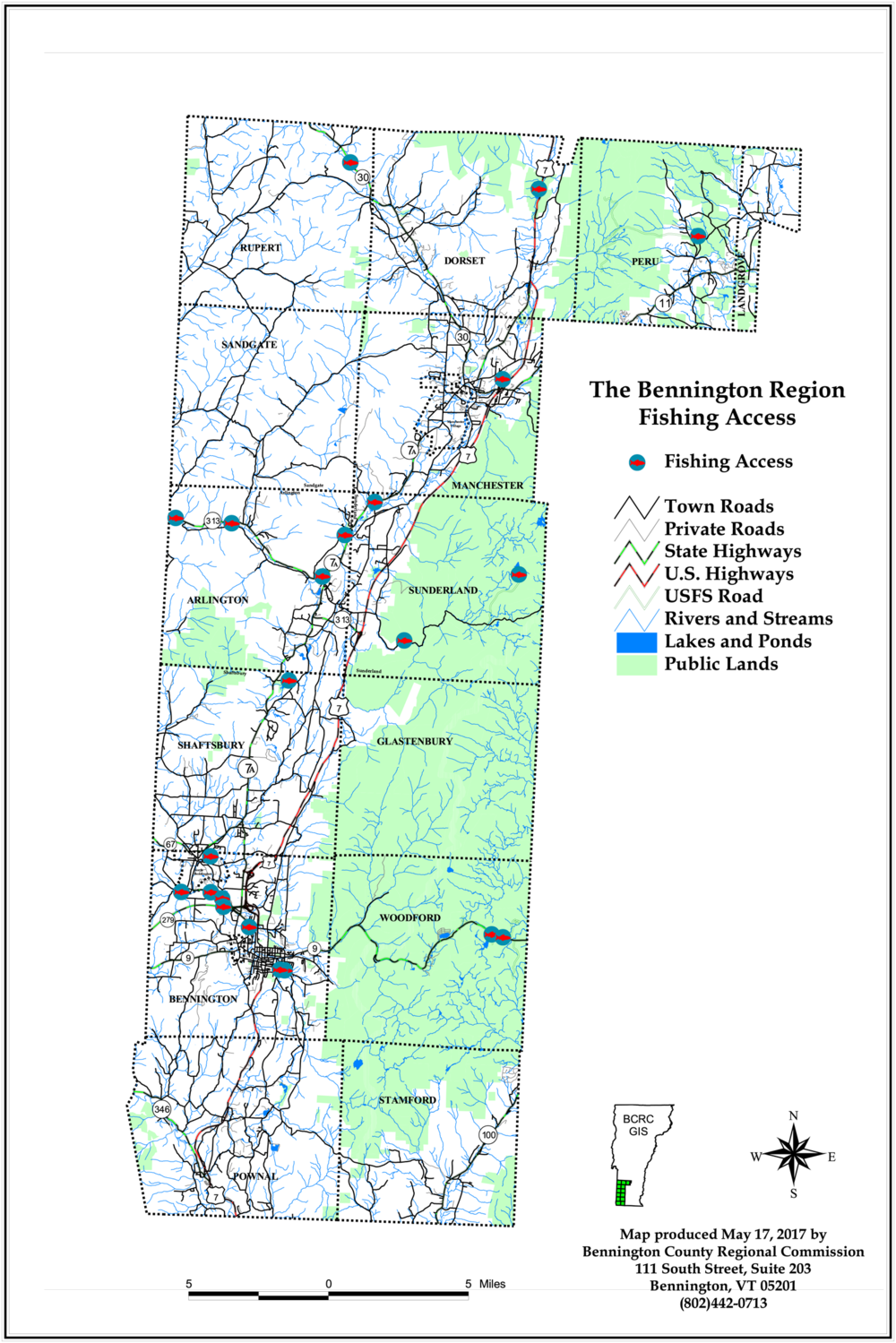
Bennington County | Fishing Access | DOWNLOAD